
News Releases
Upcoming Events,
- Rural Summit Planning Committee Meeting – Debrief, Friday, December 12, 225, 1:00 pm to 2:00 pm – Virtual
- RMC Youth Engagement Committee Meeting, Tuesday, December 16, 2025, 10:00 am to 11:00 am – Virtual
- Rural Maryland Foundation (RMF) Meeting, Thursday, December 18, 2025 – Virtual
Other Information
-
- Share your perspective and help shape the future of rural Maryland. Take the survey today.
- Are you interested in having the Council sponsor your initiative? Click here to submit your request!
- “Unlock a World of Learning” with the Maryland State Library for the Blind and Print Disabled (LBPD)
- Learn more about the Rural Maryland Foundation
- Get information about Partners for Rural America
Click on the map below to view your geographic area.
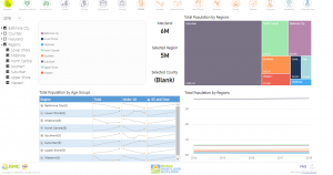
Rural Maryland Outlook is an interactive dashboard that is designed to showcase key demographics for each of the State’s 18 designated rural communities as well as the six rural regions to communicate to policy and lawmakers on how rural regions in Maryland are doing individually both currently and overtime.
Click here to become a member today!

Get involved and learn more about the great work RMC does across the State by becoming a member. Becoming a member not only allows you to learn more about RMC but also provides an opportunity to engage directly with our efforts. It’s a chance to a part of something meaningful and make a difference in your community.
Take time to navigate —
RMC Territory Map
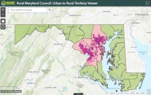
This application was developed using a cluster analysis of address point data for Anne Arundel County, Baltimore City, Baltimore County, Howard County, Montgomery County, and Prince George’s County. The data layers in this application can be used to view the rural, semi-rural, suburban, and urban areas in Maryland. Select the map or click here to view the Urban to Rural Territory Viewer.
Transparency in Action —
Meeting Minutes & Agendas
Click here to view upcoming discussions, decisions, and plans that shape our community—your input matters! Join the conversation to help create meaningful change and stay informed about initiatives that affect you and your neighbors.
Discover Support for Your Ideas — Grant Opportunities
The Council provides two grant opportunities to help Rural Maryland be prosperous with thriving resources, vibrant economies, and healthy, connected communities. Click here learn more about our grant programs and how to apply this fiscal year.
Engage, Share, and Stay Updated — Connect With Us on Social Media